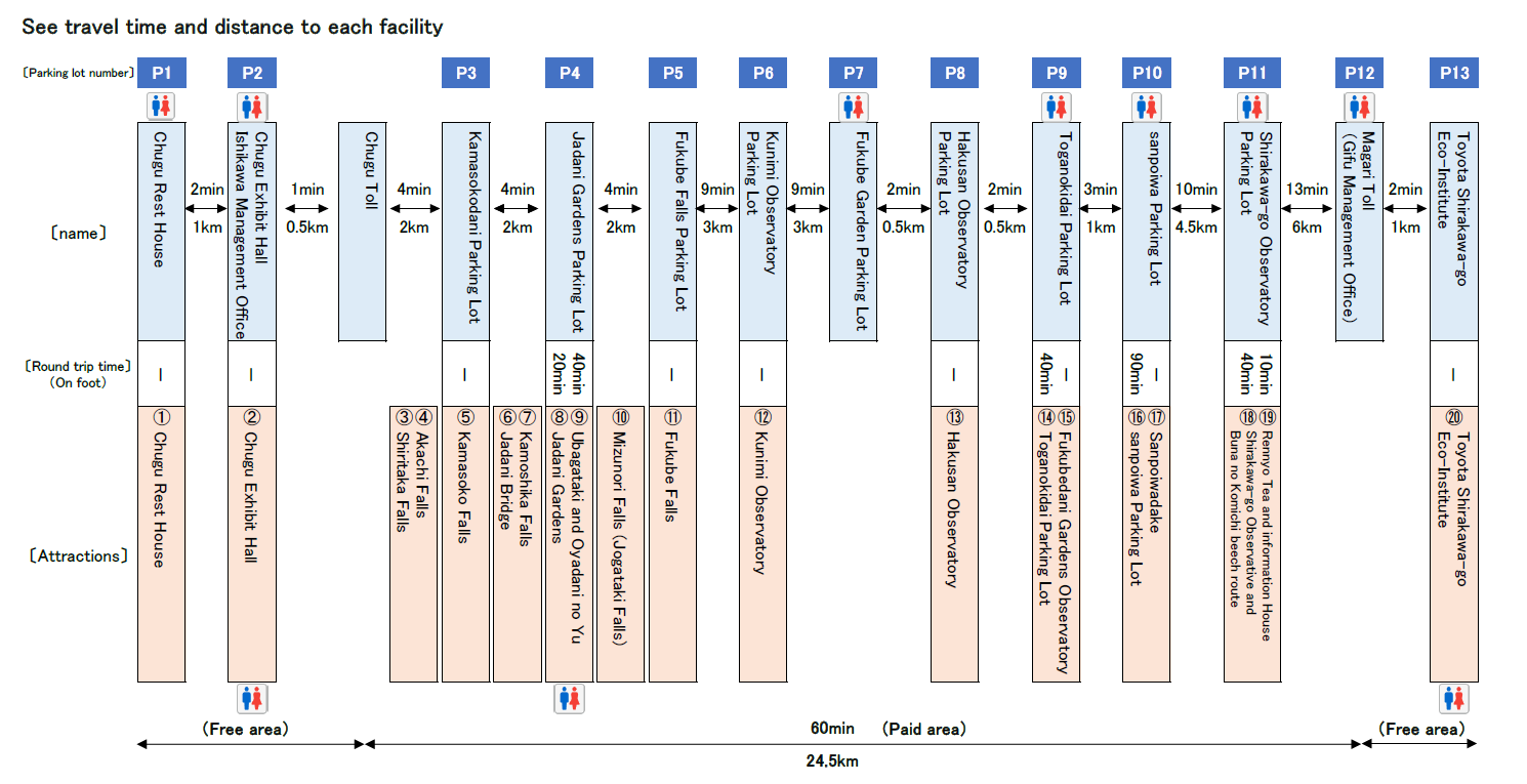
Sites to see/
facilities
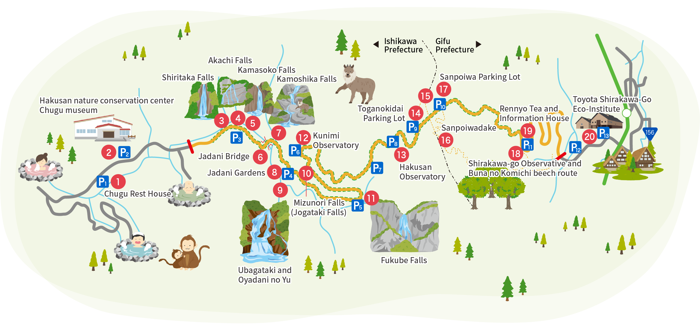
1Chugu Rest House Parking Lot
This is the first place where you can rest after getting on the White Road.
There is a large parking lot and toilets, and many people stop here to have fun down on the riverbank in the Jadani Valley during summer.
Across the Sarukohashi suspension bridge is the Nakamiya Campground, where the old-fashioned tent campsites can be used at no charge.
2Hakusan nature conservation center Chugu museum
There is a pavilion offering information on Hakusan’s flora and fauna, the formation of the Mt. Hakusan volcano, and the lifestyle and culture of the people of Hakusan’s foothills.
In addition to images, there are also mounted animals, and many experience exhibits, such as feeling the trunk of a large tree, which allow you to learn about and experience Hakusan’s nature.
In the area around the pavilion, there are nature watching trails, and Hakusan nature volunteer staff conduct guided walks (free) on weekends and holidays.
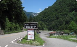
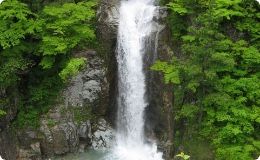
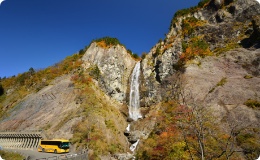
This is the first waterfall you will see after entering from Ishikawa Prefecture. Starting at Mt. Shiritaka, the flows of its water wind a silken white line across the steep mountains. The falls have three tiers; the volume and movement of water differs from where you look at it. In the morning in autumn at around 11:00 AM, you can see rainbows in the middle of the falls.
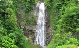
This is the second waterfall you will see after entering from Ishikawa Prefecture. When the water grows, you will see three streams resembling the strings of a guitar or Japanese “shamisen,” so the falls are colloquially referred to as the “shamisen falls.” The name “Akachi” comes from the fact that, when digging for gold, red stones were found here.
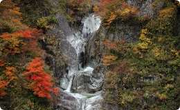
This is the third waterfall you will see after entering from Ishikawa Prefecture. Around when the new green foliage sprouts, the water level increases. In autumn, the colors of the leaves produce a beautiful canvas. There is a kettle-shaped pool at the top of the falls considered so deep that it can suck up a tree, which is where the name Kamasoko (kettle bottom) comes from.
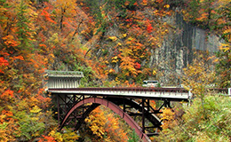
The only bridge running across the Jadani River Gorge. This bridge is 70 meters up and 45 meters long, greatly enhancing the beauty of the valley views. Near the bridge, you will see unique columnar formations caused by chilled volcanic rock. Beyond the arch is a cliff face composed of these columns, as well as views of the Tokuzure Valley. The scenery is simply exquisite during the fall foliage season, almost like a painting.
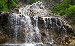
This is the fourth waterfall you will see after entering from Ishikawa Prefecture. These falls are also called the “five-stepped falls” or “five-colored falls” for the five tiers they have. The falls get their name from the high concentration of Japanese serow, or “kamoshika,” a protected species that inhabits the area.
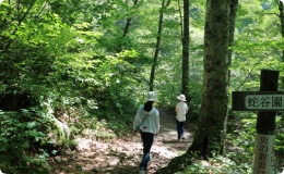
Located about 10 minutes down the stairs from Jadani Garden Parking Lot (P4) is a primeval forest of beech and water oak trees said to be 200 years old. Next is Ubagataki Falls. You can take a stroll while taking in a view of the pure waters of Jadani Valley on the riverside footpath on the way to Oyadaninoyu.
9Ubagataki and Oyadani no Yu
Selected as one of Japan’s 100 Best Waterfalls, Ubagataki Falls is reputedly named for resemblance of the narrow white stream over the bare rock to the white hair of an old woman. The Oyadaninoyu natural hot spring is located in front of the waterfall, and you can enjoy the view of the falls from the open-air baths and foot baths.
Nearby, you can also see rare sinter cones and hot water spewing up from the riverbed.
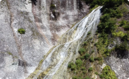
As you head from Fukube Falls Parking Lot (pg. 5) towards Jadani Gardens Parking Lot (pg. 4), you will find this stunning waterfall above and right before entering a tunnel. The falls are also likened to an “old man” in order to provide a contrast to the “old woman” falls of Ubagataki.
With an 86-meter drop, the waterfall spray sometimes splashes as far as the road, and this is the most famous spot on the path.
There is an observation deck right near the parking lot, so you can take in the dynamic view of the water flowing over the precipice. Before the road was built, only local people could see this secluded waterfall, and it was named Fukube (which means “gourd”) because there is another large waterfall above.
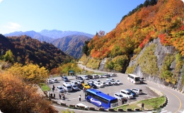
Adjacent to the Kunimi Observatory Parking Lot (pg. 6) is this observatory, with beautiful views at 1,100m above sea level. In addition to views of Hakusan, this popular foliage spot also lets you see the White Road snaking across the mountains.
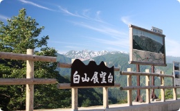
Located at the Hakusan Observatory Parking Lot (pg. 8), this is the best site to see the highest peak of Hakusan (Gozengamine, 2,702m), Onanjimine (2,684m), and Kengamine (2,677m). Below you is a vast virgin beech forest, with views of the new green foliage and autumn leaves.
14Tsuga no Mokudai Parking Lot
Located at an elevation of 1,400 meters, this parking lot is near the Ishikawa-Gifu Prefecture border on the Ishikawa side.
A primeval beech forest stretches out nearby, and across the parking lot, there is a perfect spot for taking photos which offers a beautiful view of Mt. Hakusan. This is also the starting point of the trekking route up the slope of Mt. Sanpoiwadake, and the Fukubedani Gardens Observatory along the way offers a view of Mt. Hakusan and Mt. Sanpoiwadake.
15Fukubedani Gardens Observatory
Located a 25-minute walk from the Toganokidai Parking Lot, the observatory is surrounded by a majestic 360° panorama with views of Mt. Hakusan and Mt. Sanpoiwadake in the distance.
In 2018, a new trekking route to Mt. Sanpoiwadake (Musubi no Kodo) was built where you can enjoy seasonal flowers, as well as a tunnel of autumn leaves in the fall.
From Sanpoiwadake Parking Lot, you can ascend a mountain route (50 minutes) to reach this peak at 1,736 meters above sea level. See a 360 degree view of Hakusan, the “Northern Alps” (Tateyama, Hotakadake, Norikura, etc.), as well as mountain plants like the day lily and virgin forests. Sanpoiwadake is a rock face looking out on three points (Hida, Etchu, and Kaga), which gives it its name (“Three Points Mountain”).
Located at the highest point on the Hakusan Shirakawa-go White Road (1,450 meters above sea level), this point is on the prefectural border with Gifu Prefecture. You can ascend the mountain trails (50 minutes up, 40 minutes down) and make a route between Sanpoiawadake. On clear days, you can see Japan’s “Northern Alps,” and the Hakusan Shirakawa-go White Road is the place to see the fall foliage ahead of other areas.
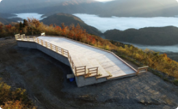
18Shirakawago Observatory Deck Buna no Komichi
There you will find the spacious Shirakawago Observatory Deck (tentative name) made from timber, and it will be completed with accessible toilets, commemorative art objects, and other features in the fall of 2022.
Located 10 minutes on foot or 20 minutes by wheelchair from the parking lot, the observatory deck offers a sweeping view of the mountains of the Shirakawago world heritage site, and you can see other mountains like the Tateyama peaks on clear days.
If you are lucky, you can also encounter a sea of mist enshrouding Shirakawago as far as the eye can see in the early morning.
The primeval beech forest which spreads out nearby has a walking path, called Buna no Michi, which takes 30 minutes to complete a round trip, so you can also enjoy forest bathing.
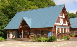
19Rennyo Tea and information House
The Rennyo Chaya teahouse inside the Shirakago Observatory Parking Lot is the only rest facility in the paid area, selling food, snacks, and all kinds of souvenirs. The “Information House” has sightseeing information on the surrounding area as well as the White Road, and in most years, it hosts a collaboration event with Atsui Machi Tajimi called “the Song of Wind Chimes,” filling it with the cool tones of many ceramic Mino-ware wind chimes as the “Hall of Wind Chimes.”
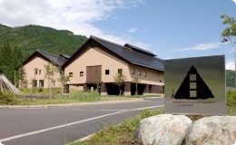
20Toyota Shirakawa-Go Eco-Institute
This “experience and accommodations” facility in the rich natural environment spread across the foothills of Mt. Hakusan offers fun for all ages, with full-time interpreters always on duty, providing nature experience programs on the theme of “coexistence of the community with nature” to the many visitors to Shirakawago, including the children who will be responsible for the future.
Summary of facilities found on Hakusan Shirakawa-go White Road
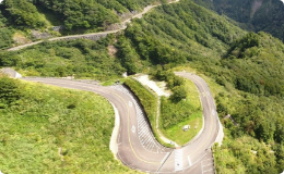
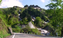
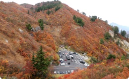
The White Road opened in 1977 and acts as a forest route where untouched natural resources are preserved. It links Ishikawa Prefecture and Gifu Prefecture. The road spans from Ozo, Hakusan, Ishikawa Prefecture to Hatogaya, Shirakawa, Gifu Prefecture, for a total of 33.3km in length (about 1 hour travel time). The exquisite views have led to this route being used for scenic purposes, and you will find large tour buses plying the route. The roads are open from early June through November 10 (varies by snowfall), and are sometimes closed due to inclement weather. You are guaranteed to find waterfalls on the waters flowing into the main branch of the Jadani Valley. The largest is Fukube Falls, which descend from a point 86 meters up. Ubagataki Falls have been selected as among Japan’s 100 finest waterfalls. Their appearance suggests an old woman letting her white hair sway to and fro. In addition to these two waterfalls, there are also ones in the “eight views” of Jadani.
In spring, you can see views of new green foliage and remaining snows on Hakusan. In summer, enjoy beating the heat in this cooler area and going on treks. In fall, you can enjoy the autumn foliage and “sea of clouds” around Shirakawa-go, as well as the natural beech forests. Unfurling below you is the village of Shirakawa-go. These and other charms await on the White Road.
You will find large and small parking lots along the route (include multi-purpose restrooms at some), letting you enjoy a convenient drive.
Along the Sanpoiwadake Parking Lot, you will find mountain plants like Hakusan rhododendron. On the waterfall viewing point at Fukube Falls, you will find Hosta montana, tiger lily, Cypripedium japonicum, mountain harebell, Chrysanthemum japonicum, and Sanguisorba hakusanensis.
Scope
- Extended 33,331m(
Ishikawa Prefecture 18,591m,
Ishikawa Prefecture 14,740m)
- Paid area 24,531m(
Ishikawa Prefecture 14,091m,
Ishikawa Prefecture 10,440m)
- Free area 8,800m(
Ishikawa Prefecture 4,500m,
Ishikawa Prefecture 4,300m)
- Width (two lanes) 6.5m
Summary
- Opened: 1977
- Extended (paid and free routes)
- Width: paved two-lane road
- Called the Hakusan Super Forest Road between 1977 and 2014 and the Hakusan Shirakawa-go White Road since 2015
Facilities
| Parking lot number
|
Name |
Parking capacity |
Restrooms |
| Light and standard vehicles |
Micro |
Large |
Men (urinal) |
Men (Japanese toilet) |
Men (Western toilet) |
Women (Japanese toilet) |
Women (Western toilet) |
Wheelchair accessible |
Multi-purpose |
| P1 |
Chugu Rest House |
52 |
0 |
7 |
9 |
0 |
2 |
0 |
8 |
0 |
0 |
| P2 |
Ishikawa Administrative Office |
49 |
0 |
5 |
5 |
0 |
2 |
0 |
4 |
0 |
1 |
| Chugu Observatory |
4 |
0 |
1 |
0 |
5 |
0 |
2 |
| P3 |
Kamasokodani Parking Lot |
24 |
1 |
0 |
0 |
0 |
0 |
0 |
0 |
0 |
0 |
| P4 |
Jatani Gardens Parking Lot |
37 |
0 |
3 |
0 |
0 |
0 |
0 |
0 |
0 |
0 |
| P5 |
Fukube Falls Parking Lot |
10 |
1 |
2 |
0 |
0 |
0 |
0 |
0 |
0 |
0 |
| P6 |
Kunimi Observatory Parking Lot |
37 |
0 |
0 |
0 |
0 |
0 |
0 |
0 |
0 |
0 |
| P7 |
Fukube Upper Garden Parking Lot |
32 |
3 |
0 |
3 |
0 |
1 |
0 |
3 |
0 |
0 |
| P8 |
Hakusan Observatory Parking Lot |
17 |
0 |
0 |
0 |
0 |
0 |
0 |
0 |
0 |
0 |
| P9 |
Toganokidai Parking Lot |
40 |
0 |
4 |
5 |
0 |
1 |
0 |
5 |
1 |
0 |
| P10 |
Sanpoiwa Parking Lot |
51 |
6 |
5 |
4 |
0 |
2 |
0 |
4 |
1 |
0 |
| P11 |
Shirakawa-go Observatory Parking Lot |
69 |
5 |
3 |
9 |
2 |
1 |
7 |
1 |
0 |
1 |
| Shirakawa-go Observative |
1 |
0 |
1 |
0 |
2 |
0 |
1 |
| P12 |
Magari Tollgate Parking Lot |
50 |
8 |
5 |
3 |
0 |
1 |
0 |
3 |
0 |
1 |
| P13 |
Toganokidai Shirakawa-Go Eco-Institute |
54 |
0 |
2 |
2 |
0 |
0 |
0 |
2 |
1 |
0 |
| Total |
522 |
24 |
36 |
45 |
2 |
12 |
7 |
37 |
3 |
6 |


